From Village to Suburb – New Book Published

Featured

So much fascinating detail about places all around us”

For many centuries Fulwood was a small community, remote from Sheffield. Over the period covered by this book it was transformed into a suburb fully integrated into the City.

Focussing on the landowners, the builders and the people who lived in the new houses, the book gives a vivid picture of a diverse community over the 60 years up to the second world war.
Copies (cost £12.99) are available from

Record of FHG Meeting 18/12/25

Record of FULWOOD HISTORY GROUP MEETING 18th December 2025

Present:  D.A., N.B., A.C., M.L., D.M., K.P., J.P.

Business Matters:

  1. The anniversary payment for the FHG website will be due soon
  2. Keith suggested that the Group should hold its next meeting at a restaurant: this was agreed

Items:

  1. Matthew reported that he had been digging in the garden of Broomhill Library
  2. We welcomed Neil Birchenall to the Group. He gave a short history of Stanage Lodge which he owns and lives in along with his family. The house has needed substantial renovations. It is completely off-grid, the house is surrounded by land belonging to the Duke of Rutland.There was a brief discussion about the location of Fulwood Booth. The conclusion was as is shown on the OS map (Fulwood Booth to SE of eastern-most reservoir):

OS map Redmires Reservoirs with Fulwood Booth to their SE

History:

1854: Lumley Lodge is to the right of the map. Reproduced with the permission of the National Library of Scotland https://maps.nls.uk/

  1. 1700s known as Lumley Farm, later Lumley Lodge
  2. Until 1977 the Lodge was owned by a member of the Wilson family (Snuff mill fame)
  3. 1977 sold. Was locaton of Redmires Shoooting Club. Financial problems meant owner’s bank foreclosed the mortgage
  4. 1977 – 2023 owned by another family. At end only Jane remained in house
  5. Neil and family restoring the house. Caming barn & cottage(s) for rent being developed.
  6. Property is completely off grid for power, water, etc.
  7. Partnership with Rutland (duke) and Yorkshire Water that has moors for the future spend
  8. Neil showed a website: ‘property market intel’ which is a subscrition App showing who owns land. Private Owners’ details are not displayed but corporate owners are detailed.
  9. Other locations were mentioned:
    1. Fairthorne Lodge owned by Daniel Doncaster. Was for a time a holiday location for children e.g when mother had newborn
    2. Grouse & Trout was known as Whitehouse Farm

Next meeting to take place at Valencia restaurant 15.1.26


Record of FHG Meeting 20/11/25

Record of FULWOOD HISTORY GROUP MEETING 20th November 2025

Present: J.B., A.C., G.C., M.G., M.L., D.M., K.P., J.P.

Discussion included:

1) MG: Scissors, Paper, Stone provisional programme for 2026: interpreting wills, occupations recorded in documents and their significance e.g. gardeners, hierarchy of servants, implications of phrase “country girls preferred” used in newspaper advertisements for servants

2) Ranmoor society catalogue: ongoing progress with this; clarification that archives store original material while local studies library tends to keep printed materials

3) JB shared some extracts from Transactions of the Unitarian Historical Society Part I, Oct. 1937 & Part II, Oct. 1938; they give a sense of Fulwood’s remoteness pre-20th century, and of its connection with Derbyshire towns and villages rather than with the town of Sheffield

4) GC shared John Wilson’s The Songs of Joseph Mather (Sheffield, 1862). Mather (1737-1804), a file-cutter, wrote ballads which provide a social commentary of late 18th-century Sheffield; he also wrote a song called The Nether Green Lad which GC read to us; a more recent collection of Mather’s songs is called Seditious Things (Kay and Windle, 2017)


5) KP told us about developments regarding local planning permission

6) Update on Fulwood Spa investigation (AC, ML): more information and images shared; could the features have included a WWII lookout? Were they associated with ski runs?

Next meeting 18th December 2025


176 Oakbrook Road

A few days ago, I was asked if I knew anything of this property by one of the residents. This is what I found.

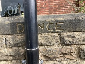
The property is at the end of terrace that was built about 1902. It is of a different design from the rest of the terrace as it combined a shop on the ground floor with accommodation on the upper floors. It is unique in that it is separated from other shops at the Junction of Oakbrook Road with Hangingwater Road.

Robert Burrell and his wife Emily were the first occupants. Robert, a native of Leicestershire was born in 1872. By 1891 he was working as farm servant in Blakeney, Lincolnshire and living in the household of Thomas Burr, an agricultural Labourer, who occupied a tied cottage on the farm.

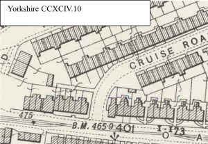
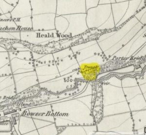
OS map showing the plan of the shop

Like many young people, Robert moved off the land hoping for more opportunities in a city like Sheffield. By 1901 he and Emily were married and living in Pitsmoor. Robert was working as a Market Salesman. To supplement their income, Emily was running a boarding house, providing accommodation for four young men, with three from Lincolnshire and indeed two from the same village. So it is possible that these single men knew Robert from his days as a farm worker.

Thrift and hard work paid off for Robert and Emily and they were able to take on this newly built shop in a rapidly developing suburb, developing a business selling fruit.

Street directories, published yearly, record that Robert and Emily had the business from about 1905.

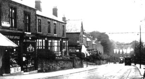
The shop – with a white awning

Robert and Emily did not have any children

Robert died at the house in December 1931 ‘after a long a painful illness very patiently borne. After a funeral service at Ranmoor Wesleyan Church, his body was buried at Burngreave Cemetery.

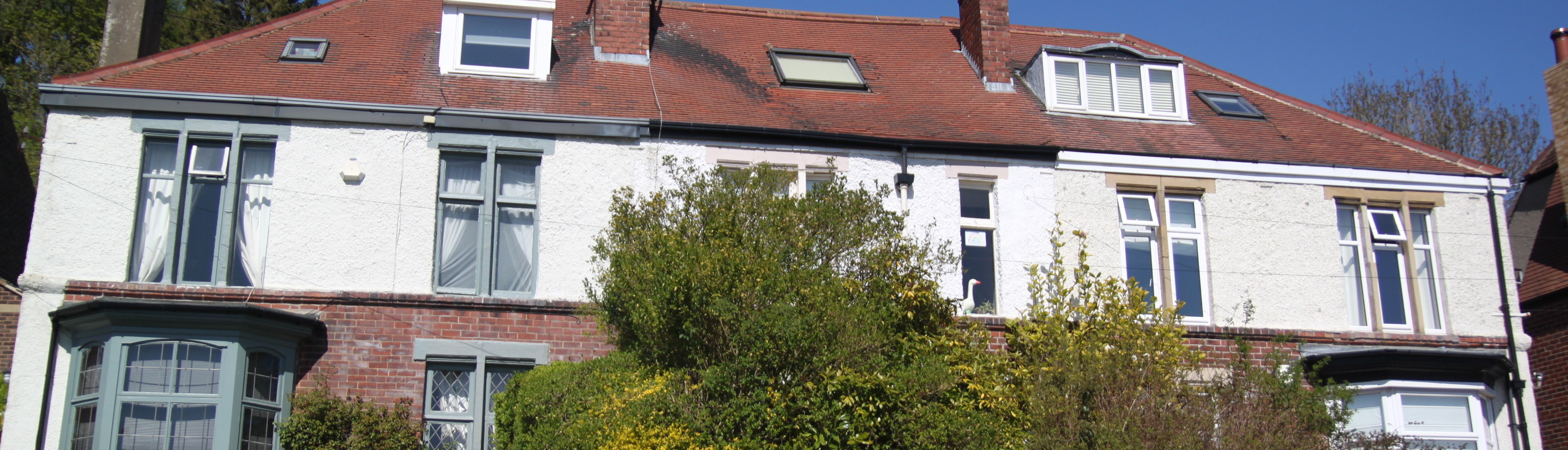
Emily continued to run the fruit shop until after Robert’s death. Her death in November 1943 occurred at the house she had lived in for just under 40 Years. With no descendants to continue the business after Emily’s death the property was converted into two residences [1] . It was recently sold and some renovation was carried out.

[1] Warr: The Growth of Ranmoor, Hangingwater and Nether Green, page 126
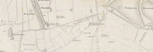
Record of FHG Meeting 16/10/25

Record of FULWOOD HISTORY GROUP MEETING 17th October 2025

Present: D.A., J.B., M.L., C.M., K.P., J.P.

At our first meeting since the summer and back in Broomhill Library, our discussion included:

  • Archaeological dig in Broomhill Library Garden taking place (ML)
  • University of Sheffield Landscape Architecture students’ project based on Broomhill and its library
  • Visit to Turner Museum of Glass at University of Sheffield
  • Cruciform design seen in stone posts in the area:
      Glossop Road, Broomfield Road, Stumperlowe Hall Road, and a variation of the design in Mount View, Glossop Road
  • Oak Brook and its lost footpath
  • Springs and structures in wooded area near Woodcliffe. D.A. shared findings of recent investigation undertaken with A.C.
  • Trough ‘discovered’ by J.B. between Whiteley Woods & Woofindin Road
  • Based on information from Trade Directories, the relatively large proportion of gardeners living in the area in the late 19th and early 20th centuries (K.P.)
  • J.B.’s blog re Ranmoor Market available on Scissors, Paper, Stone website
  • Next meeting 20th November 2025

Record of FHG meeting 17/7/25

Record of FULWOOD HISTORY GROUP MEETING 17th July 2025

Present: D.A., J.B., G.C., M.L., C.M., D.M., K.P., J.P.

This was our second summer meeting on the top field at Forge Dam

  1. History & background of G.C.’s house on School Green Lane and how it had been developed
  2. Recent arson at Fulwood House which has caused significant damage to the building
  3. DM told us about a folder of information collected over the years by owners of former Hammer & Pincers pub on Old Fulwood Road
  4. KP led us on a walk around Brookhouse Hill and lower Chorley Road
  5. Next meeting tbc


Record of FHG meeting 19/6/25

Record of FULWOOD HISTORY GROUP MEETING 19th June 2025

Present: D.A., J.B., A.C., G.C., S.C., R.F., A.H., C.M., K.P., J.P.

We met on the top field at Forge Dam

  • History & background of land relating to Forge Dam field and lower Brookhouse Hill
    • Whitelely Lane, known as Chapel Lane, had been widened in the length fronting the chapel and graves were removed from this space – when was this?
    • A quarry had occupied space we were seated on – late 19th and early 20th centuries – the entrance had been somewhere just below Brook House
    • The Hancock family of builders had a plan for substantial area housing in this space; Hancock went bust in early 30s J.G. Graves Trust bought the land, so it was protected from development
    • See Pitchforth From Village to Suburb photo ‘Looking up Brookhouse Hill about 1920’, p.125, ‘School Green Lane and Whiteley Lane’ p149, ‘Continuous Change’, p.157
    • AC had discovered a Sale notice: MINATURE GOLF COURSE AND TENNIS COURTS at FULWOOD and WHITELEY, SHEFFIELD: which covered an area bordered by Whiteley Lane, Quiet Lane and Brookhouse Hill. It refers to ‘the WHITELEY WOOD MINATURE GOLF COURSE and 2 HARD TENNIS COURTS and small Hut’ and that it ‘forms an excellent site for a public institution, or the erection of Villa Residences’
      • There had been tennis courts in the 1930s on the raised section of the field, but they could have belonged to the houses built there – not public
      • Mini golf may have taken place on the lower area of field next to lower Brookhouse Hill (Lea Lane)
    • Was the field used for allotments during WWII?
    • There had been an orchard in the area where Muriel Hall’s bungalow was  built; MH’s bungalow has been extensively redeveloped

1850s Reproduced with the permission of the National Library of Scotland

1938/47 Reproduced with the permission of the National Library of Scotland

  • JB shared information from an enquiry sparked by a postcard from July 1908 sent by Florence Wilson nee Dixon of Stumperlowe Hall and then Tapton Hall; Florence addressed the card ‘Fulwood House’ – where her brother James was living at the time; it was sent to a what seems to have been a friend, (Ada Nicholson), who lived in Manchester; see KP’s post about Fulwood Hall on this website
  • GC shared childhood memories of Tapton Hall, particularly its water feature, (fed by the Oak Brook) and the substantial trout it contained
  • AC’s Substack piece on Brook House is available here: https://alancrutch.substack.com/p/brookhouse-brook-house
  • AC then led us on an exploration of the cluster of buildings where Brookhouse Hill meets Whiteley Lane which include Brookhouse Farm, Brook House, Brook Lea, Brook Lodge and the former coffee house (Brook Cottage?). He told us about the people who lived in this area known as ‘Brook House’, (recorded in the late 1700s ‘Brook Hause’) or ‘Brook House Green’. ‘Brook House’ did not refer to one building, as it does now, but to a whole area or hamlet. Crimicar Lane was recorded as Brook House Green in the 1850s.
  • KP’s post about 127 Brookhouse Hill explores the upper end of this road
  • We walked up to the Ale Club, noting the ‘DANCE’ inscription
  • See also: https://alancrutch.substack.com/p/dry-fulwood which includes history of the Fulwood shops area.

  • Next meeting tbc

Record of FHG meeting 29/5/25

Record of FULWOOD HISTORY GROUP MEETING 29th MAY 2025

Present: J.B., A.H., M.L., C.M., D.M.

This month’s meeting took the form of a walk to explore ideas for September’s Heritage Open Days theme of architecture. This is the route we took:

  1. Old Fulwood Road: former Hammer and Pincers/smithy c. late 18th century cottage?
  2. Woofindin Road: comparison with modernist building[1] and attitudes towards ‘old’/’modern’ architecture (p. 63 Pitchforth 2024[2]), urban exploration and its contribution to heritage, former NHS building fire 23rd May
  3. Across road to Slayleigh Lane:
    • wooden supports under eaves of houses lining Fulwood Road (modillions?)
    • Newfield Court (date?) on site of former parsonage
  4. Stumperlowe Mansions (late 1930s) modernism e.g. clean lines, use of steel & brick (from local brickworks?), symmetry, verandas with S decoration, design of entrance and windows; concierge and vicarage wall/remains of garden (pp 168-9 Pitchforth 2024[3])
  5. Continuing along Slayleigh Lane up to Stumperlowe Lane: houses in very similar style to Stumperlowe Mansions scattered around this area – built at same time/same architect?
  6. Moving up Stumplerlowe Lane into area of former farmland, farms and cottages
  7. Stumperlowe Grange – view of long driveway; Broom Lawn built on its land
  8. Onto Stumperlowe Hall Road with an entrance to Stumperlowe Hall – design carved into gateposts based on castle arrow slits; differences in brickwork suggesting changes to entrance; guardstones
  9. Side of Stumperlowe Grange with stained glass and date of 1863; its outbuildings e.g. Appleby House
  10. Across road and complex of buildings which were part of Stumperlowe Hall estate: Stumper Lea, cottages – one with cruck, gateposts
  11. Noted frequency of buildings in area names referencing trees
  12. Tall chimney of Deepdene
  13. Demolition and rebuild of houses in area
  14. Pause at junction of Stumperlowe Crescent Road: view of range of architectural styles – Arts and Crafts; original distinctive style of trellis
  15. House set back in trees near crest of hill: similar style to Stumperlowe Mansions; view of Ranmoor spire somewhere here?
  16. Following Stumperlowe Hall Road round with Griffin Sick over wall in grounds of Stumperlowe View Farm
  17. Range of architectural styles visible from this junction of Stumperlowe Hall Road and Chorley Road, incl. contemporary, 2-year-old house which follows earlier styles – details of brickwork
  18. Following Stumperlowe Hall Road a little further up to catch site of Stumperlowe View Farm and gennel which follows old footpath which leads into Upper Ranmoor
  19. Back down to dip of road junctions and then follow ascent of Chorley Road with new builds
  20. Great Gilling with its stone face; Highlow; Stone Delf referencing former quarry
  21. Towards junction with Slayleigh Lane and on Slayleigh Lane itself: houses reminiscent of Metroland style with their arched doorways
  22. Down Slayleigh Lane with Fulwood Sports Club and Bowling Club Pavilions c.1911
  23. House with raised roof
  24. Meeting junction with Stumperlowe Hall Road and view of Stumperlowe Hall main entrance – note avenue of trees leading up to entrance,
  25. Down Stumperlowe Hall Road towards Fulwood Road: herringbone brickwork, former Bowling Green House at number 97
  26. Windy Corner/Arthwadson House which was showhouse for 1930s Arthwadson estate (pp 166-8 Pitchforth 2024[4])
  27. Good view of Guild Hall and Storth Cottage from this finishing point

Architectural info: terrace, cottage, villa, semi-detached, detached, Tudorbethan – beginning in the Edwardian era, continuing through the 1920s and 1930s, ‘debilitated Queen Anne style’[5], Illustrated Glossary of Architectural Terms, Glossary of Architectural terms,

Next month’s meeting 19th June at Broomhill Library tbc.

[1] For information about Sheffield’s modernist buildings: https://modernmooch.com/

[2] Pitchforth, K. (2024). From Village to Suburb. A History of Fulwood between 1880 and 1940. Arc Publishing

[3] ibid

[4] ibid

[5] Page 21, Edwards, A. 1981. The Design of Suburbia. Pembridge Press