Fulwood gets its own Railway Station – nearly!

The idea was raised by William John Lindley C.E. of Sharrow Lane Sheffield in May 1899. His aims were mostly social, replacing many of the worst slum areas of the city with a brand-new railway, pleasure gardens and land for development of better housing for “reasonable and just conditions of life of the working classes of all degrees.”

The Sheffield Independent carried several letters about the project including one from the proposer indicating his estimated cost to be a little over £1,000,000 and a scheme whereby the capital and interest costs of construction could be recovered.
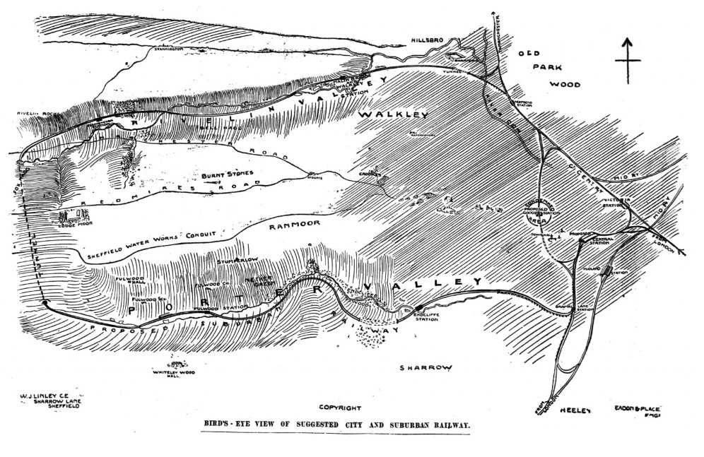
Graphic map of the proposed route

The scheme never received any official support but would have enabled those living in the city to enjoy a trip out to the Porter or Rivelin valleys and return home the same day. Below is shown the proposed route.

A rather grand new central station was to be built in Fitzallan Square in addition to the Midland and Victoria stations that were already established in Sheffield. The following illustration gives an indication of how it might have appeared:
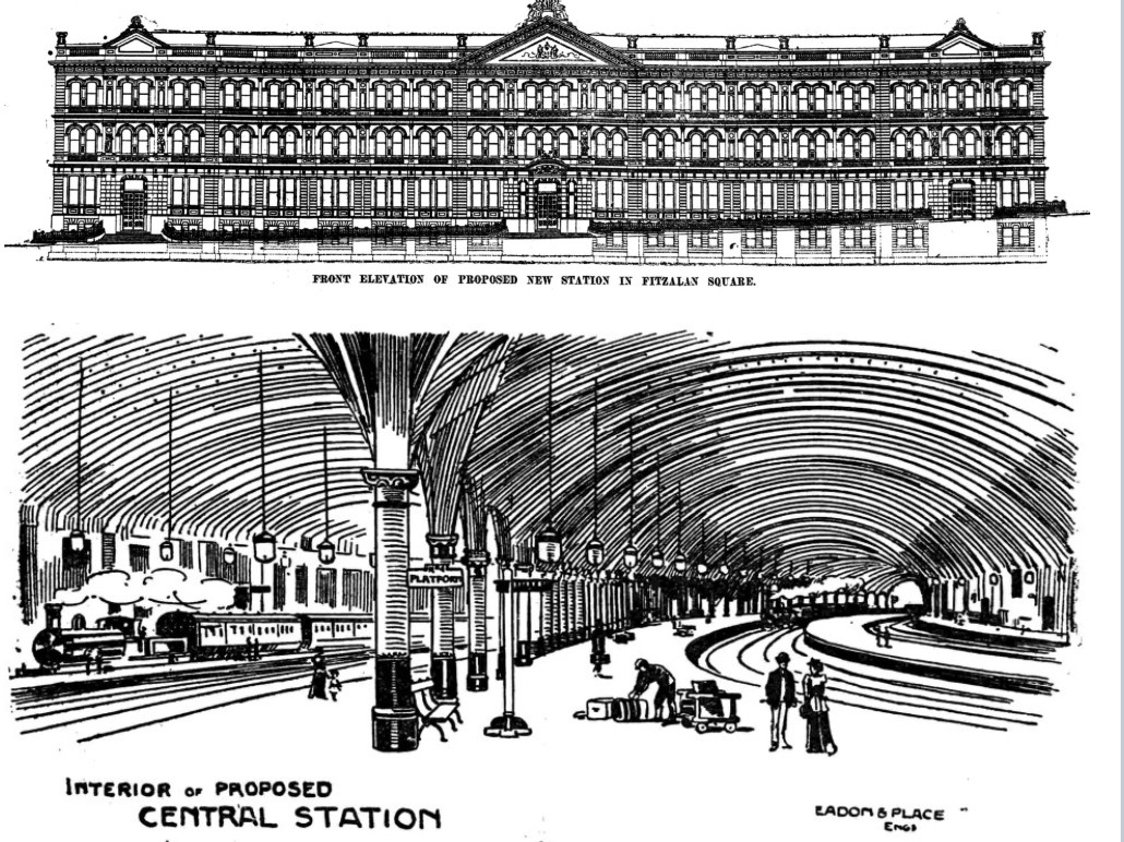
Ideas for the city centre station

The circuitous route would have involved the construction of several new stations as well as the above. From the new Central Station the line would travel to stops at Bramall Lane, Endcliffe and Fulwood before leaving the Porter Valley to pass through an underground tunnel below Redmires Road, at a point a little way past Lodge Moor Hospital to re-emerge in the Rivelin Valley where it would stop at Stannington so passengers could explore the delights of Rivelin Rocks before passing on to Walkley and Malin Bridge Station. The train would then enter another tunnel before emerging at Neepsend station. It would next call at Victoria Station at the Wicker, which would be the connection to the wider rail network, before returning to the Central Station. No doubt it would have been a pleasant day out on a fine summer’s day.

What would the effects have been on Fulwood if the proposal had been adopted? Probably very little as the tram network was, by 1899, already bringing visitors as close as Nethergreen where they could travel by foot to enjoy an afternoon boating at Forge Dam or one of the other entertainments offered by Herbert Maxfield who owned the Dam site.. Afterwards visitors might enjoy a slice of cake while waiting for the tram at the establishment next to the terminus owned by the Oates family of Fullwood Hall. The only advantage the proposed railway might have had is that the proposed Fulwood station was nearer the Porter. This might have been good for the area of the various dams but Fulwood itself was some way off and up a very steep hill and it is doubtful how many visitors would want, or have time to, explore the delights of Fulwood itself. The site of the proposed station would also have been inconvenient for Fulwood residents at the beginning of the 20th century. If it had been built and was a success though maybe Fulwood would have extended down to the Porter Valley where there would now be shops and housing developments of all times.

The idea perhaps came a little too late. By 1899 railways had certainly lost any novelty value and Fulwood developed along the existing roads rather than around any new railway station.

Alan Crutch
23rd April 2023

Ringinglow – Industry

This is the last of four posts giving a brief history of Ringinglow

Brown Edge Quarries

Joseph Andrews of Green House Farm was listed as the quarry owner in White’s Directory of 1841. In 1845 Philip Andrews was a coal-owner and farmer in the area. The quarry had been operating since at least 1836 and produced good quality stone slates for roofing, flags and building. About 1860 it was owned by a Mr Chaddock then by Sam Hancock, an older relative of the Fulwood monumental mason. Later it was owned by his brother Henry some of whose actions have already been described. The quarry closed about 1873.

The Deep Sick Coal Pits.

About 250 yards west of Moorcot cottage and on the same side of the road as the Round House, was the first of two Deep Sick coal pits. Deep Sick was the name given to the start of the Fenny Brook which became the Limb stream. Shale and pudding holes were found approximately opposite the Ring o’ Firs farm and a shaft was later sunk a little further away, about 600 yards west of the Norfolk Arms. Both workings lie inside Lady Cannings Plantation. The coal was wound by a hand windlass and the tubs were pushed along the pit bottom over stone flags. It is thought that coal workings began at the time of the Dore Common Land allotment between 1809 and 1822.

Robert Trotter was married and living at Carr Houses in Fulwood when he started the Deep Sick coal pits, building a shed in which to sharpen tools near the first workings south of the Norfolk Arms. He traded his coal for lime from the lime workings at Stoney Middleton but he said that carters and others ‘pinched’ the coal so he came to live on the job and added a parlour to the cabin, so making ‘two stories lengthways’. He was helped in the business by his only son George. The land formed part of the Dore common enclosure allotments so he very reluctantly had to pay 5 shillings a year for his occupation of the house which, by then, was jokingly called Moorcock Hall. The payment did however entitle him to half yearly free dinners for all such tenants at the Rutland Rent audit held at the Peacock Hotel at Owler Bar, even though it disbarred any claim he might have had to squatters’ rights over the house. When Robert died his widow and son had the payment increased to three guineas a year. They could, though, rent out the mining rights.

The coal workings were abandoned by 1862 and the 1851 Dore census records George Trotter. aged about 67 being described as a coal-miner pauper, so it seems that mining was ceasing to be profitable for some time before the final closure. The Trotters remained in the house until Hiram’s widow moved out in 1887 and the house is reported as being abandoned between 1887 and 1892 according to one of her sons. It was demolished around 1911 with some of the stone used to build Mr Priest’s house, Moorcot, which was built on an adjoining plot.

The coal obtained from Ringinglow was of an inferior quality. Herbert Trotter reported that one load of the coal would produce ‘two loads of ashes and one of soot’. The local saying was that ‘you could boil owt and roast nowt’ with it. It also had a high sulphate of iron content which meant that sometimes it would explode with a crack sending burning pieces across the room. Herbert likened it to being at the 1854 battle of Balaclava.

There was another coal pit near Carsick Grange about 200 yards east of Carsick Hall.

The Wire Mill

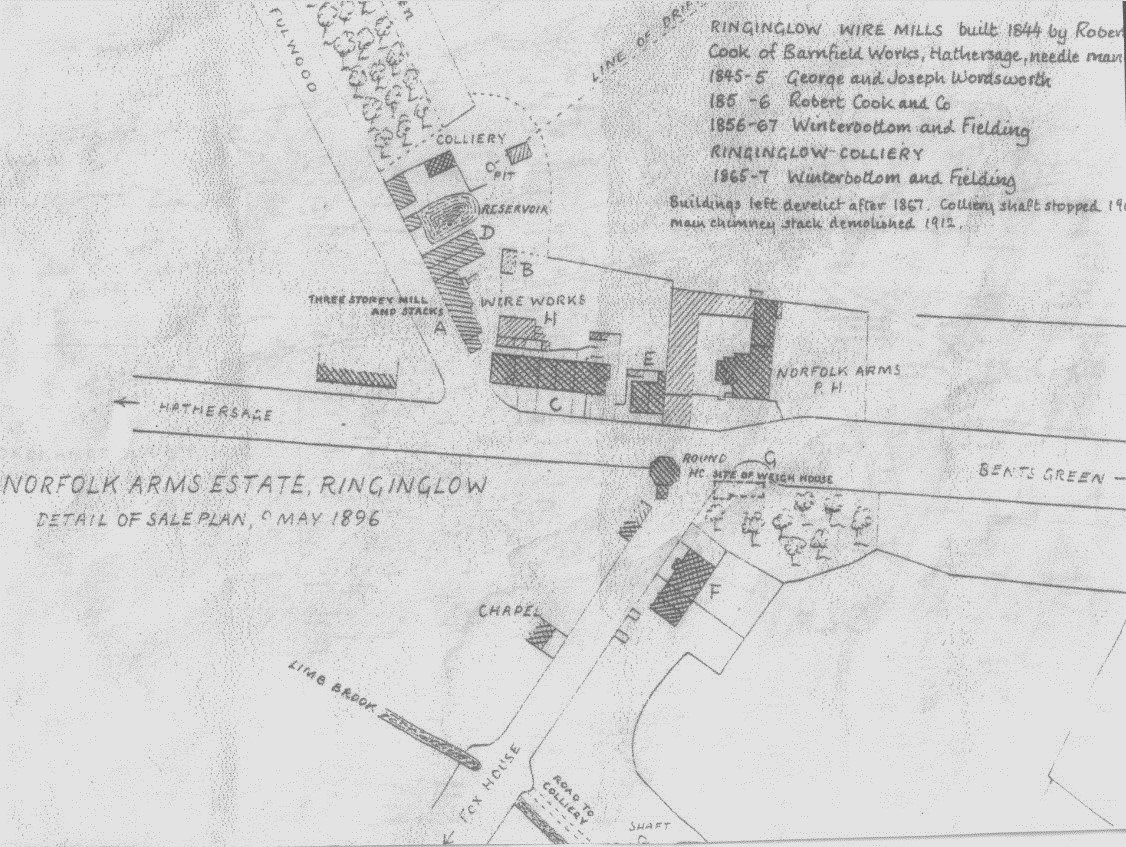
The Wire Mill was constructed on land immediately behind the row of terraced houses next to the Norfolk Arms with access from Fulwood Lane. A detailed layout is shown on the 1896 plan

The Mill was constructed in 1844 by Robert Cooke of Bamforth. George and Joseph Wordsworth operated there from 1845 until 1855 and Robert Cooke’s manager George Winterbottom of Batley took over the works and entered into partnership with a man called Fieldsend. They were advertising for workmen in 1862 in the following terms

“Wanted. Several cast steel wire drawers to draw from Nos 1 – 12 Needle Wire”.

Less than two weeks later there was a fire at the works. Rumour has it that it was caused by disgruntled workers from the Mill who believed it to be uninsured. That may in part explain the letter written to the editor of the Sheffield Daily Telegraph by the employers at the Mill.

The letter thanks all those who assisted in containing the fire. Mr W Swift for spotting it, Mr Charles Marsden, the Norfolk Arms landlord for organizing a party to contain the fire and stopping it spreading until the fire engines arrived. Engines came from the Sheffield Fire Office and succeeded in containing the blaze to the building in which the fire started without it spreading to the other mill. A considerable amount of valuable property was also saved from the debris through the perseverance of Mr Staniforth, the captain of the Sheffield Fire Brigade.

The last paragraph of the letter may well be sending a message to those responsible for the fire. It reads

“We also feel it is our duty to publicly state that the Sheffield Fire Office, with whom we are insured, have, through their secretary, Mr Esam, satisfactorily and promptly settled our claim and thus enabled us to proceed with our business without unnecessary delay”

It is signed Winterbottom and Fieldsend, Ringinglow, and dated 25th November 1862.

The plan also shows at its. Northernmost point, a colliery. An advertisement in 1860 invited investors to contribute towards an intended mine on the site which was to have a shaft of approximately 50 yards to be sunk.

Mining seems to have been carried on spasmodically. Winterbottom and Fieldsend used the coal mined to power the mill but their involvement ceased in 1867. A sale of the Wire Mill and the colliery complete with plant, steam engines boiler and boiler house, as well as other land, was advertised for sale in 1882. In 1901 the North end of the pit was deemed unsafe and blocked up, and the site was demolished along with the chimney which bore the date 1844, in 1912.

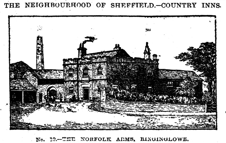
The chimney is shown behind the Norfolk Arms in the photograph that appeared in the Sheffield Independent of 13th February 1886. It is said that the lightning conductor on the chimney, after demolition, was made, by Hiriam Trotter, into toasting forks for everyone in Fulwood.

Ringinglow – People

This is the third of four posts giving a brief history of Ringinglow

Henry Kelly

A little away from Ringinglow along the road to Burbage Bridge and at the junction with Oxstone Dale Road there stood an old two-up two-down cottage. Mr Preston built the cottage and had a business processing locally dug peat that was pressed to form potash manure with the aid of an engine and small boiler. He sold the potash manure from his premises.

Preston employed an Irishman, Henry Kelly and his wife, Bridget, who moved into the house when Mr Preston left the country after the business failed. Kelly was supposed to pay rent but never did. Preston returned briefly but soon left again after taking a watch from Henry Trotter’s sister, Mrs Flint of Bower Hill (and several others) which he promised to repair but never returned.

Kelly kept chickens and goats and cleared a patch of moorland where he attempted to grow oats, which ever grew to more than 6 inches high according to Henry Trotter, and potatoes. It seems that if you were a mate of Kelly, you could ‘send for a drop of good watter fro’ Kelly’s’. The excise men never did discover the illicit still.

Kelly also worked at Brown Edge quarry and carried slates on his back in a saddle padded with straw to a spot where they would be exposed to frost and would ‘weather’ before ‘scabbing and striking’ (scaling and splitting) into the required sizes.

Kelly’s house seems to have been a popular place with the local quarrymen . There were several ‘sprees and beanos’ at the house or at the quarry. When at Kelly’s there were ‘usually several fetchings of beer’ presumably from the Norfolk Arms.

There was a tradition amongst the Brown Edge quarrymen concerning the first bumblebee of the summer. When the first bee of the year was seen, the owner of the quarry, Henry Hancock, put five shillings to the men’s two shillings and somebody was detailed to take an empty barrow to the Norfolk Arms and return with several gallons of beer.

Kelly’s son, Barney, played the concertina with a ‘band’ made up of a fife, tin whistle, and a Jew’s harp. There was plenty of singing, shouting, and clapping by the 40-50 quarrymen. Kelly sometimes felt that they had overstayed their welcome and they would play Irish songs to try to ‘bring him round’. When that failed the party would be ended by Kelly fetching his old carbine gun! The quarrymen could get rowdy and once flew a black flag from Kelly’s chimney and then hid in the heather to watch the bemused occupant’s reaction.

One year the men were at Kelly’s, larking with Kelly’s two buxom daughters, Catherine and Mary Ann, and his two sons, Pat and Barney when Kelly returned home and tried to turn them all out by brandishing a steel bar. Two men were saved from physical injury by the intervention of Henry Hancock the owner of Brown Edge Quarry, who held Kelly’s head up the chimney, over the peat fire, ‘until he cried for mercy.’ Once released, Kelly did eventually drive them all out with the aid of his steel bar and his trusty carbine.

Eventually, the freehold owner of the land (the Duke of Norfolk) was demanding payment due to him as the freeholder which was much in arrears. At this time Kelly was seen taking brass and scrap parts of the old peat engine and boiler away for sale in a cart pulled by his old donkey. The police followed him to the Hammer and Pincers once but could not succeed in a prosecution because the whereabouts of the owner of the machine, Mr Preston, was unknown and Kelly maintained that he had been ‘dead these twenty years’. Eventually the Kelly’s were evicted in 1876/7 and the property fell into disrepair.

Trotter retold story that Kelly tried to get rid of his old donkey by trying to get it to back itself into an old Moss Coal pit. The donkey refused to co-operate. Its subsequent fate is unknown.

Kelly’s son, Barney, was not averse to a little poaching. A gamekeeper, William Fox, of Far Bassett Farm off Andrew Lane (now Andwell Lane) had long suspected him and hid in the heather and waited for Barney to appear.  Barney duly shot and picked up the dead bird. The gamekeeper stood up and Barney not only fled the scene but went straight into the army where he remained for the next twelve years!

Robert Trotter and Moorcock Hall

Robert Trotter was Herbert Trotter’s great-grandfather. He was born in Berwick in c 1784 and he and his parents moved south to Durham to work a corn mill. The story goes that young Robert was kidnapped by coalminers and taken to Barnsley to work in the mines there. He escaped and found work with a Sheffield farmer. He helped to sink his first coal pit in Ecclesall. Trotter spent some time developing a coal mine at Ringinglow. This story will be picked up in the next post.

Community Spirit

In 1872, Charles Staley, a quarryman, of Ringinglow was charged with a serious assault on a prominent industrialist, the manager of Bessemer & Co in Sheffield. Charles Staley was arrested for the assault because his sister had been dismissed as a cook at the industrialist’s home in Endcliffe Crescent only a few days before. His alibi was that he was at the Norfolk Arms at the relevant time. Ten witnesses went to Court to testify on his behalf and it seems the men made a collection to help the recently widowed mother of the accused who was totally financially dependent on her son who was living with her but unable to earn anything while he was being remanded in custody. Thanks to their support Charles Staley was found Not Guilty.

Lightning Strike

On July 1912 Sarah Helen Silcock was aged 23 and helping on her uncle’s farm at Yarncliffe when she was struck by a sudden bolt of lightning that killed her instantly. The others present felt the blast and were thrown to the ground but all survived. Most of her clothing was burned and one stocking was reported to be still smoking when the survivors went to her body. The field where this happened was never mowed again during the Silcocks’ occupation.

Buildings of Ringinglow

This is the second of four posts giving a brief history of Ringinglow

The Chapel

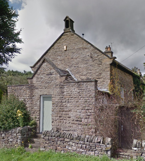
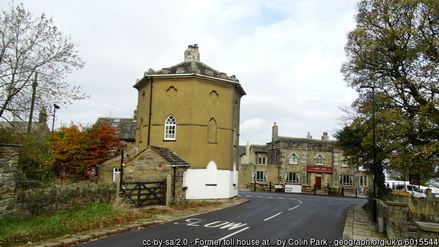
The chapel stands along Sheephill Road from old toll house. It was opened on 31st March 1864 the result of the efforts of Hugh Garside Rhodes, the minister of the Independent Chapel in Fulwood. Rhodes was born in 1790 and in the 1860s sometimes preached to a congregation of one. Herbert Trotter reported that Rhodes’ father used to preach in his absence. Here, Trotter’s recollection may not be accurate as the 1861 census records Hugh Garside Rhodes (born 1790) as an Independent Minister and head of the household, with Hugh Garside Rhodes (born 1838) as a banking clerk. So perhaps it was the younger Garside who preached in his father’s absence.
The lads made fun of the elder Garside. Once he left the pulpit to break a stick over the head of a boy named Latch, although Herbert admits that he was the one that caused the incident.

For a few years, the chapel housed a night school.  By 1868 the trustees were trying to persuade Sheffield Education board to take it off their hands at no cost and to open it as a day school, the Board paying the Trustees just for the desks etc. Nothing came of this and the chapel was disused for about two years before an unsuccessful revival attempt was made in 1874. Following the death of Mr Rhodes, the building was taken over in 1886 by Fulwood Church.

The Round House and The Norfolk Arms

What is now Ringinglow Road was first made a turnpike in 1758. It was the principal road out of Sheffield to the Peak District and Lancashire for the rest of the 18th century and therefore quite prosperous. An Act of Parliament in 1795 authorised a toll house to be built on land belonging to the Duke of Norfolk, just inside the boundary of Upper Hallam. Increased tolls and new toll bars were also part of the Act. These were the Hathersage toll bar on the west side of the Houndkirk Road junction and the Houndkirk Toll bar on the south side of Houndkirk Road. The Round House appears on a plan of the parish dated 1795 so it is likely that the new bars were in place at the same time.

Herbert Trotter said that ‘the Norfolk Arms’ was built between 1820 and 1830’, but according to Muriel Hall, the battlements at the Norfolk Arms were added to match those of the Round House ‘shortly after 1803’. As the Norfolk Arms does not appear on the 1795 plan the inn was probably built sometime between 1796 and 1803.

In 1819, the ‘Northern Star’ reported that the round house and the inn were both castellated ‘as though they marked some important barrier’. The same two buildings feature again in 1844 in the book ‘Walks in the Neighbourhood of Sheffield’. On the subject of Ringinglowe, the author states that there is:

“A good house of entertainment on one side of the road and an unseemly tower on the other side which, until these few years past, served as a toll house and lodged the keeper and his family.”

The Round House with the Norfolk Arms

A new road to the Fox House via Dore Moor, built in 1816 reduced the traffic through Ringinglow and the roads were reduced from Turnpikes to Parish roads in 1825.  The Round House ceased as a toll house and was sold.

By 1840 it was part of the Rawson’s Brewery Empire which owned the Norfolk Arms. It seems as though the founder Thomas Rawson was interested in the potential of Ringinglow as a Rawson is named as a tenant of the Duke of Norfolk in 1795. The land was developed as the ‘Ring o’ Firs Farm’ and may have included a roadside alehouse. This was possibly Rawson’s first venture in Ringinglow before his building the ‘Ringinglow Inn’ later to be known as the ‘Norfolk Arms’.

‘T’ Ring o’ Firs’

About 400 yards W of the Norfolk Arms in the direction of Burbage Bridge on the R side of the road was a small walled-in ring of trees. Larches grew there until they wer felled in c1870. The circle wall inside the field (c12 yards in diameter) was pulled down c1883 by the farmer Henry Broomhead who lived in Ring of Firs Farm which was on the site of the last two houses at the W end of Ringinglowe . The curve of the part of the wall adjoining the road was still there in 1921 and also appears to be there today. Henry Broomhead became the Landlord at the Norfolk Arms, just down the road.

There is a legend concerning the site of the ‘Ring o’ Firs’. One wintry Tuesday night, the first of the month, a man travelling over the Moors was lost and in despair when he heard the bells from Sheffield Parish Church (now the Cathedral) being rung. This gave him a sense of direction and he reached safety. The ring of trees is supposed to be where he first heard the bells. In gratitude, the traveller made a bequest of a piece of land to the church to ensure that the church bells would be rung on the first Tuesday evening of every month.

For a time the bells were rung on Tuesday evenings in the winter months (from the Doncaster horserace meeting to Shrove Tuesday), but there is record of any such charitable bequest. Leader dismisses the legend as ‘a pretty romance’

As already mentioned, the Ring o’ Firs Farm may have been a roadside ale house before the Norfolk Arms was built. The archway over what is now the end cottage door of the terrace shows that this was probably a barn serving the farm which may date from around 1800 after the land around was cleared following the local enclosure act award in the 1790’s. Another such alehouse was Mount Pleasant Farm at the top of Andrew Lane and farmhouses in Fulwood such as David Lane Farm (T’ Oil in t’ Wall) Jeffrey Green Farm and The Three Merry Lads opened during the construction of the Redmires Reservoirs.

Ringinglow – Early Years

The roadside hamlet of Ringinglowe began life after the 1757 Road Act established a road from Sharrow, Psalter and High Lanes to Ringinglow before dividing. One section went along Houndkirk (Ankirk) to Fox House. The other went to Upper Burbage Bridges and Hathersage.

There were sporadic attempts to develop industry which with the exception of quarrying were not successful.

This post, covering the early years will be followed by posts covering the significant buildings, some ‘people’ stories and industry

Sources

In the 50th anniversary booklet of the Sheffield Clarion Ramblers, published in 1950, G H B Ward. recorded conversations with the late Herbert Trotter in 1921 when Herbert was 62. The article in the booklet is the basis for this brief history of Ringinglow

Herbert Trotter was born at Fernfield Farm located on the south side of the Sheffield to Fox House Road near Dore. He spent his youth and early adulthood in Ringinglow. He was a stonemason who could quarry, hew, dress and fix his own work. He wore the old-fashioned trade-sign of white woollen cord trousers cleaned with bath brick.

Newspaper reports, plans held in the Sheffield Archives and Muriel Hall’s ‘Mayfield Valley’ also provided information.

Early Years

‘Ringinglawe’ was mentioned in both 1574 and 1637. On 6th August 1574 it was viewed to confirm the boundaries between Hallamshire and those of Ecclesall and Hathersage. The relevant section was ‘from the great stone called Stomperstocke to the great heap of stones called Ringinglowe’ (from which Robert Lee had taken many of the stones being ‘by one sick or brook that parts Derbyshire and Hallamshire’. The brook is likely to be the infant Whirlow Brook, known in the region as ‘Fenny Brook’. This places the stones as being a little way along Houndkirk Road, between the Norfolk Arms and Moorcot. Harrison’s survey of that 1637 both mentioned ‘Ringing Lawe’ and ‘Stowperstorke’

Modern facilities were slow in arriving in Ringinglowe. The octagonal toll house ‘The Round House’ was probably built in around 1760. The old Weigh House, opposite the Round House was pulled down before 1922. Herbert Trotter says that the tolls were let on an annual basis and the old toll-keeper moved into the Weigh House until the next toll-keeper lost his job. In Herbert Trotter’s youth the Weigh House was used to house a Dame School kept by Mrs Lawson assisted by Billy Winterbottom who was ‘the big lad and chucker-out’.

Notes of FHG Meeting 16/11/23

Present: JB, ML, CM, J&KP

1 Remembrance Day ceremony which took place at Fulwood War Memorial on 12th.

  • People involved
  • Land around the war memorial – ownership and use

2            FHG website update

  • Connected to importance of keeping record of our meetings
  • Way to keep relatively large number of people connected
  • Design, accessibility, structure and functionality: Matthew took notes
  • Posting and adding longer articles
  • Current contributions to the site
  • Looked at C. Jenkins’ Stumperlowe article on site and wondered about source of this and the ‘Stump’ burial story

3   Archaeological connections: Matthew shared pictures of neolithic (?) quern-         stone sites on Ringinglow moors from his work with Dr. Tim Cockrell and team from Sheffield Uni; led to discussion of rock art in Ecclesall woods and elsewhere in our area

4 Discussion around nature of our memories and our histories

5 House numbering: included Stand’ area and racecourses in Broomhill & Redmires

6  Rights of way and local developments included

  • Field behind Scout Hut
  • Artic Monkeys

7  Looked through Histories ‘n’ Oddities ‘r’ Old Fulwood (HOOF) – booklets 1, 6 & 7.  These were written, (probably over the last decade), by Susan Hedges who used to live at Beech Dene cottages

8  Future plans

  • Next meeting – Thursday December 21st – mince pies?
  • Set out rough plan for future meetings, including large ones
  • To develop knowledge for collecting oral histories
  • Possibility of having a ‘booth’ at events to collect people’s recollections

Ancient Fulwood

Fulwood was only developed as a suburb of Sheffield towards the end of the 19th century and that, in itself, is an interesting story, but this article is about Fulwood in the dim and distant past. An extract from the 1850/1 OS map reproduced at the end of this short article will give you an idea as to how Fulwood was before it developed as a suburb of Sheffield

Pre-History

The story begins in the Mesolithic age when people were nomadic following the herds of wild animals and collecting nuts, plants and berries. They probably fished in local rivers and streams. An attractive area for both wild animals and early man, Fulwood would, as its name suggests, have been mostly covered in trees with many streams and rivers. Evidence that people were present consists of finds of flint here. A scraper was found in one of the fields below School Green Lane and a microflint was found near to where Blackbrook Avenue currently stands.

The story is similar in the Neolithic Age which began in around 5000 BC. A barbed arrowhead was found in one of the fields near Lodge Lane and another significant find has been made near the road up to Ringinglowe.

People were also here in the Bronze age (c2,500 BC – 800 BC) Yet again the Blackbrook Avenue area seems to have been particularly favoured as there are was evidence of both barrows and cairns in that region, and another near Cottage Lane.

The Roman Period

Enormous stones still form the base of old field walls in this area. These may date back to the Romano-British period (c50 AD – 400AD) and possibly earlier. A marble mosaic, roman pottery and what is described as an opus signium have all been found near Lodge Lane and a Roman coin of Constantine has been found in Stumperlowe. Roman pottery and evidence of a small building have been discovered at the top of Brooklands Avenue.

The Medieval Period

Aerial photographs show that several fields in the area have the ridge and furrow pattern typical of medieval farming and the early Court Rolls for the manor of Sheffield contain numerous references to families that had settled in Fulwood. The oldest names the Lynott family as taking 3 acres of land in Fulwood in 1283. As the Rolls only began to be compiled in the 1270s it is almost certain that this region was lived in and farmed well before that date. The monks from Beauchief Abbey had land in this area and Fulwood Booth is reported as being a place where the Lord of the Manor’s oxen were being raised in the 12th century.

Tudors and later

By the time of the Tudors (from 1485) there were several established families living in and farming land in Fulwood. As their wealth increased several of them seem to have begun to build more substantial houses. In the early 1600s they seem to have been competing as to who would live in the grandest house. Benet Grange, Fulwood Hall, Stumperlowe Hall and Whirlow Hall all seem to have been substantially improved at that time.

The story of Fulwood continues to the present day. In the twentieth century there were plans to run a railway connection to Fulwood and it was also proposed that the South-Western part of the Sheffield Ring Road should pass through Fulwood very near to the field opposite the chapel.

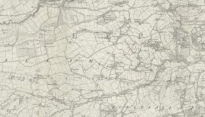
First Ordnance Survey of the area carried out in 1850 and published in 1854 (click on the map to see the on-line map). 

First Ordnance Survey of the area carried out in 1850 and published in 1854 Reproduced with the permission of the National Library of Scotland


The Tip at Fulwood (1908)

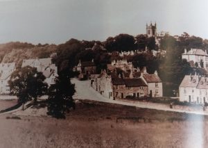
Signs of Fulwood becoming a suburb were evident by 1908. Crimicar Lane and Brookhouse Hill had new housing and Silver Birch was being developed. The photograph shows the junction in the early C20th, the foothpath that would be superceded by Brooklands Avenue is on the left and the houses, also on the left of the picture, are at the bottom of Crimicar Lane. The land  for these houses had been purchased by Samuel Hancock from Henry Isaac Dixon of Stumperlowe Hall in 1905. The land in the west of Crimicar Lane drops away from Brookhouse Hill.
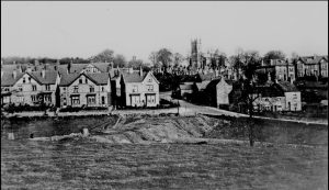
The plans to create Brooklands Avenue were in existence at least from the early years of the new century: a plan of land being sold by Henry Isaac Dixon’s executors in 1913 shows the proposed road and the ramp is clearly shown on the picture of 1912 to the right.
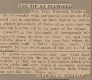
But the new residents of Fulwood valued its rural nature and the sight of rubbish being tipped did not go down well. The independent reported on the 18th March that ‘there is some protest which is growing’ over the use of refuse ‘of an objectionable kind’ being used for road building. Charles Needham, newly established in a villa opposite the church initiated the flurry of letters to the editor of the Daily Telegraph (the Idependent and the Telegraph were not averse to printing articles as direct copies of that found in their rival’s newspaper) . Needham’s letter was written soon after the tipping began and takes a swipe at Dixon as the landowner who had permitted and was being paid for allowing the tipping. T D Nichol was quick to support Needham, writing as soon as he read Needham’s letter. The rubbish being tipped was from households as the reference to ‘tined meat cans’ shows.
An Election Issue

October that year was a time of elections to the City Corporation and the candidates claimed and counter claimed as to who had ‘stopped the tipping of night soil’ with the Telegraph reporting that despite the claims of Coucillor Ashmore to this, it was in fact the landowner, Dixon, who had stopped the tipping. The independent, more supportive of Ashmore reported at length on his rebuttal of the earlier claims. There had been correspondence between Ashmore and the Town Clerk with the Clerk confirming that he had instructed.

The Telegraph investigated the matter, rather than relying on letters received and reports of hustings meetings, and on 29th October. Its report confirmed that James Dixon (son of Henry Isaac Dixon) had requested the tipping as he wanted the land raised to the level of the road. John Smith, living opposite at 84 Brookhouse Hill, was ‘indignant’ and complained the Health Committee, which had agreed to Dixon’s request, The Lord Mayor and the Town Clerk. In the end it was Dixon who stopped the tipping, probably because what was being tipped was more than he expected.

The barbs continued to be exchanged through the campaign. The election took place early in November and both Nowill and Ashmore were elected.

Brooklands Avenue Today

As to the ‘ramp’ that Dixon had initially instigated, it was eventually completed and became Brooklands Avenue. I suspect that most people who visit the shops at Fulwood are not aware that the Avenue is built up. However, the next time you visit the hardware shop (or any others on the same side) take a look a the paved area. There is a void underneath which can be seen between the vacant shop and the house. On the other side, the access to the garage drops away from the road.

And finally, T D Nichol whose letter to the Telegraph was featured in a Facebook page seems to be ficticious. I cannot find him an any census or street directories of the period. Neither can I find a reference to a house named Lynwood on Crimicar Lane.

But both Charles Needham and John Henry Smith definitely were ‘real’ and feature in the records

Ariel Photos of Fulwood

These ariel pictures were taken by the RAF about 1948. The aircraft was flying south so the Hallamshire Golf Course is at the bottom of the picture. The road to the right of the picture is Crimicar Lane with the Isolation Hospital in the centre. The unfinished road is Barncliffe Road with Barncliffe Crescent curving away behind the hospital.

On the left edge of the photo in the midlle is the curve of the top of Hallam Grange Road with the Crescent just visible towards the top. The conduit is across the upper part of the photo

This second photo has Hallam Grange Road just left of centre and appproximately on a north-west to south east axis. At the junction with slayleigh Lane (therew is no Hallamshire Road at thgis point) is the original site of the Hallam Grange Tenis & Bowls club. The Hallam Grange EstATE WAS BEGUN IN THE Late 1920s but interupted by WW2. The order of building suggests that different builders were involved.

Some of the footpaths visible in these photos still exist

A Pen Portrait of Stumperlowe (Circa 1990s)

The article appeared in the Sheffield Spectator. It was found by a member of the Group and it’s been re-formatted from its original 4 column format.

A Kind of Hush – Clare Jenkins explores the distant past of a tranquil Sheffield Suburb

A friend recently found herself in Stumperlowe one Saturday, looking for the Soroptomists’ jumble sale. It was an unsettling experience. `”What a weird place.” she whispered nervously next time we met. “Very Stepford Wives…”

Wander round Stumperlowe even on a weekday, with the sun shining, and you can see what she means. Large houses – the semis are substantial, while the detacheds are HUGE – set back from thickly moss-covered pavements, hidden behind laurels and variegated conifers. standing unblinking and remote at the top of neat lawns.

The first thing you notice is that it’s very quiet in this, one of the city’s most ancient districts. There’s muted bird song, the rustling of leaves, the whoosh of the odd squirrel leapfrogging over wrought iron gateposts, plus the purr of the occasional car. But there are very few people. Not on foot. anyway- Why should there be? There are no shops here, no community centre, no bus stops. no church – it’s halfway between St John’s. Ranmoor and Christ Church, Fulwood. Nothing. that is. to walk to. So the inhabitants either stay indoors behind the Austrian blinds, or glide out of their driveway in their indispensable cars.

In a morning of zig-zagging up and down steep Stumperlowe Streets, the only human beings I saw were three workmen renovating a perfectly decent looking house. a postman, an elderly man raking up leaves in his garden and an elderly woman returning from the postbox. The latter two both said “Good morning” in posh Stumperlowe voices. Presumably their neighbours were inside cloning.

If Stumperlowe is weird, it’s quite possibly as much to do with its distant past as with its isolated present. The name is old English for ‘Stump’s burial ground’. The Stump in question was one of Lord of the Manor Waltheof’s chieftains back in Saxon times. A sort of Stump of the Dig. And historians reckon he’s buried somewhere in the grounds of what is now – and has been since the 16th Century – Stumperlowe Hall.

Waltheof had his own hall here, in the old village of Hallam. It’s certainly an impressive site for a Saxon village, halfway up a hillside looking one way out to Ringinglow and Hallam Moors, another across the valley which now houses the city to Rotherham, a third over to Stannington and Loxley.

Up until the last century, it must have been predominantly rural, boasting just the odd mansion and farmhouse, like Stumperlowe Grange Farm, a slate-roofed low stone building now reduced to a small-holding complete with crowing cockerel. Around it is quite a collection of 1930s angles, 1950s eaves, 1960s boxed flats and the odd oak-beamed rustic refugee from Hamelin.

The Grange itself is very impressive. In 1883, it belonged to W E Layeock, Esq. JP, ex- Mayor of Sheffield. (Stumperlowe has always had more than its fair share of JPs and OBEs. Majors and Colonels. PhDs and, for some reason, haematologists.) Originally owned by General Murray ‘of the lordly Scottish house of Athol’, Colonel of the Black Watch, the Grange passed into the hands of the merchant Wilsons. By Laycock’s time, it was being described in gushing terms: “quite in the country and yet conveniently near to the town. it would be hard to imagine a more desirable place in which to spend the evening of an active and honourable life.” As you wandered around its 50 acres. you could see “the graceful spire of Laughton en le Morthen when the western heavens are aglow with the glories of autumn sunsets.” Neighbouring the Grange is a cluster of old stone houses, one of which, Stumperlowe House, boasts two splendid windows. One is engraved with the Latin Fide Non Minis and Dum Vivo Canebo. Which may or may not translate as ‘I trust not weapons’ and ‘While I live I shall sing’. The other window bears a beautiful red, gold and green stained glass design.

Just across the road, up a long sweeping drive and surrounded on three sides by thick laurel bushes, is Stumperlowe Hall itself, one of the oldest inhabited residences in the city. Although there are references to such a hall in the time of Richard II, this particular house dates back to 1657, and could serve as a model for Manderlay, Daphne Du Maurier’s haunting home of Rebecca.

In Queen Elizabeth I’s time. Robert Mitchell and his two daughters lived in Stumperlowe. The elder, Margaret, married Henry Hall of Edale, and their son Robert built the hall proper. He also became Lord of the Manor of Midhope. Unfortunately, one of his sons, Henry II, dissipated his wealth in the dissolute company of ‘Fox of Fulwood and Bright of Whirlow’. As a result, his widow and children lost the hall in 1716 to an apothecary and lead merchant. Stumperlowe Hall was rebuilt in the 1850s and, in 1947, became the home of the chairman of the Kennings business. It incorporated not only the usual library, drawing room and study but also a ‘sitting room for servants’ and a service cottage and barn, believed to be the oldest buildings in Fulwood.

In the pre-war years, the grand houses were joined by Stumperlowe Mansions, 35 service flats whose brochure talks of them being finished in a ‘quiet, dignified way. Residents had access to a lift and restaurant, while ‘dinner parties are catered for on request’ The flats themselves were furnished with sturdy 1930s chairs, drinks tables and round-edged fridges. Although, while some of the garages had central heating. this I didn’t extend to the flats. There was also a tradesman’s entrance ‘in order to mitigate the noise and number of individual daily deliveries.

Other features of Stumperlowe include white wrought iron garden furniture and fox weather vanes, caravans and double garages, rhododendrons and pampas grass. holly- and ivy-covered walls. house names like The Gables, Birch Lodge, The Croft, Hawthorns- plus one or two Eldorado monstrosities. If you find yourself up there, look out for Manx gates,  the wall with a quarry wheel embedded in it, the tree house and rope ladder. Oh, and the Stumperlowe Wives.