On a Sunday morning in March, we enjoyed a tour of Stumperlowe Mansions on Stumperlowe Lane. This was organised by a member of the group and thanks to him and to his family member who did an excellent job of showing us round.
Stumperlowe Mansions was built in the late 1930s and its architecture, like that of several houses nearby, reflects the style of the period. The development was aimed at short-stay, middle-class tenants and seemed to function somewhere between a hotel and residential flats. MoD officials were known to have lived there in its early years, keeping an eye on manufacture of arms at Sheffield’s steelworks. The Mansions were built to the latest specification and as such, gas and electricity were installed, a feature which was just becoming standard in the 1930s. [1]
Interior
We were shown the entrance foyer first. On each side of the of the entrance, there is an office where the porter would have sat, rather like a university hall of residence.
Opposite this and now boarded over, there is a lift with high-quality fixtures and fittings. The building as whole was noted for the quality of its furnishings which were supplied by local prestigious companies such as Cole Brothers.
In its heyday, the residents enjoyed communal facilities such as a restaurant and bar, as well as room-service.
Exterior
The view from the garden area at the rear of the building highlights elements of modernism , a movement which had an increasing influence on architecture from the 1930s: the symmetrical design of the building, the lack of ornament, the section of flat roof, the windows with their glass held in steel frames and the use of concrete and style of brick. Another notable feature was the garages, a block of which has become derelict. This indicates how even before WWII, private motor car usage was becoming widespread amongst the suburban middle class.
The old wall of the vicarage is still standing, marking a boundary between Stumperlowe Mansions and Newfield Court, although some of it is has collapsed.
Although there is little ornamentation, the four sets of balcony railings at the front of the building incorporate a figure ‘S’ detail. The design of Stumperlowe Mansions, with its south-facing balconies and sun terrace, might have been inspired by glamourous English riviera apartments overlooking the sea, but this does require a leap of imagination on a damp, grey Fulwood morning.
This is the second of four posts giving a brief history of Ringinglow
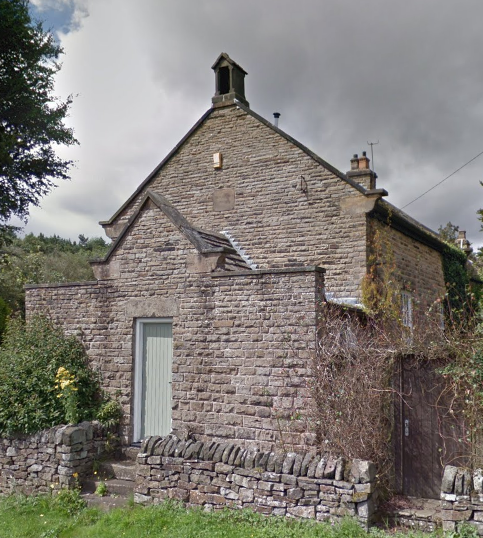
The Chapel
The chapel stands along Sheephill Road from old toll house. It was opened on 31st March 1864 the result of the efforts of Hugh Garside Rhodes, the minister of the Independent Chapel in Fulwood. Rhodes was born in 1790 and in the 1860s sometimes preached to a congregation of one. Herbert Trotter reported that Rhodes’ father used to preach in his absence. Here, Trotter’s recollection may not be accurate as the 1861 census records Hugh Garside Rhodes (born 1790) as an Independent Minister and head of the household, with Hugh Garside Rhodes (born 1838) as a banking clerk. So perhaps it was the younger Garside who preached in his father’s absence.
The lads made fun of the elder Garside. Once he left the pulpit to break a stick over the head of a boy named Latch, although Herbert admits that he was the one that caused the incident.
For a few years, the chapel housed a night school. By 1868 the trustees were trying to persuade Sheffield Education board to take it off their hands at no cost and to open it as a day school, the Board paying the Trustees just for the desks etc. Nothing came of this and the chapel was disused for about two years before an unsuccessful revival attempt was made in 1874. Following the death of Mr Rhodes, the building was taken over in 1886 by Fulwood Church.
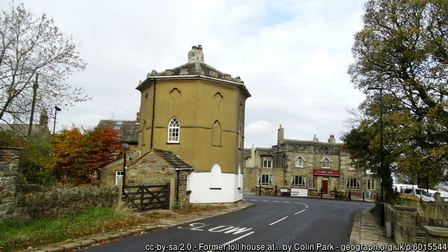
The Round House and The Norfolk Arms
What is now Ringinglow Road was first made a turnpike in 1758. It was the principal road out of Sheffield to the Peak District and Lancashire for the rest of the 18th century and therefore quite prosperous. An Act of Parliament in 1795 authorised a toll house to be built on land belonging to the Duke of Norfolk, just inside the boundary of Upper Hallam. Increased tolls and new toll bars were also part of the Act. These were the Hathersage toll bar on the west side of the Houndkirk Road junction and the Houndkirk Toll bar on the south side of Houndkirk Road. The Round House appears on a plan of the parish dated 1795 so it is likely that the new bars were in place at the same time.
Herbert Trotter said that ‘the Norfolk Arms’ was built between 1820 and 1830’, but according to Muriel Hall, the battlements at the Norfolk Arms were added to match those of the Round House ‘shortly after 1803’. As the Norfolk Arms does not appear on the 1795 plan the inn was probably built sometime between 1796 and 1803.
In 1819, the ‘Northern Star’ reported that the round house and the inn were both castellated ‘as though they marked some important barrier’. The same two buildings feature again in 1844 in the book ‘Walks in the Neighbourhood of Sheffield’. On the subject of Ringinglowe, the author states that there is:
“A good house of entertainment on one side of the road and an unseemly tower on the other side which, until these few years past, served as a toll house and lodged the keeper and his family.”
The Round House with the Norfolk Arms
A new road to the Fox House via Dore Moor, built in 1816 reduced the traffic through Ringinglow and the roads were reduced from Turnpikes to Parish roads in 1825. The Round House ceased as a toll house and was sold.
By 1840 it was part of the Rawson’s Brewery Empire which owned the Norfolk Arms. It seems as though the founder Thomas Rawson was interested in the potential of Ringinglow as a Rawson is named as a tenant of the Duke of Norfolk in 1795. The land was developed as the ‘Ring o’ Firs Farm’ and may have included a roadside alehouse. This was possibly Rawson’s first venture in Ringinglow before his building the ‘Ringinglow Inn’ later to be known as the ‘Norfolk Arms’.
‘T’ Ring o’ Firs’
About 400 yards W of the Norfolk Arms in the direction of Burbage Bridge on the R side of the road was a small walled-in ring of trees. Larches grew there until they wer felled in c1870. The circle wall inside the field (c12 yards in diameter) was pulled down c1883 by the farmer Henry Broomhead who lived in Ring of Firs Farm which was on the site of the last two houses at the W end of Ringinglowe . The curve of the part of the wall adjoining the road was still there in 1921 and also appears to be there today. Henry Broomhead became the Landlord at the Norfolk Arms, just down the road.
There is a legend concerning the site of the ‘Ring o’ Firs’. One wintry Tuesday night, the first of the month, a man travelling over the Moors was lost and in despair when he heard the bells from Sheffield Parish Church (now the Cathedral) being rung. This gave him a sense of direction and he reached safety. The ring of trees is supposed to be where he first heard the bells. In gratitude, the traveller made a bequest of a piece of land to the church to ensure that the church bells would be rung on the first Tuesday evening of every month.
For a time the bells were rung on Tuesday evenings in the winter months (from the Doncaster horserace meeting to Shrove Tuesday), but there is record of any such charitable bequest. Leader dismisses the legend as ‘a pretty romance’
As already mentioned, the Ring o’ Firs Farm may have been a roadside ale house before the Norfolk Arms was built. The archway over what is now the end cottage door of the terrace shows that this was probably a barn serving the farm which may date from around 1800 after the land around was cleared following the local enclosure act award in the 1790’s. Another such alehouse was Mount Pleasant Farm at the top of Andrew Lane and farmhouses in Fulwood such as David Lane Farm (T’ Oil in t’ Wall) Jeffrey Green Farm and The Three Merry Lads opened during the construction of the Redmires Reservoirs.
These ariel pictures were taken by the RAF about 1948. The aircraft was flying south so the Hallamshire Golf Course is at the bottom of the picture. The road to the right of the picture is Crimicar Lane with the Isolation Hospital in the centre. The unfinished road is Barncliffe Road with Barncliffe Crescent curving away behind the hospital.
On the left edge of the photo in the midlle is the curve of the top of Hallam Grange Road with the Crescent just visible towards the top. The conduit is across the upper part of the photo
This second photo has Hallam Grange Road just left of centre and appproximately on a north-west to south east axis. At the junction with slayleigh Lane (therew is no Hallamshire Road at thgis point) is the original site of the Hallam Grange Tenis & Bowls club. The Hallam Grange EstATE WAS BEGUN IN THE Late 1920s but interupted by WW2. The order of building suggests that different builders were involved.
Some of the footpaths visible in these photos still exist